Sunday, September 4, 2016

9/4/2016 British Columbia: Wines, Vancouver, Vancouver Island and Victoria

 
Vancouver Island, Mountains and Glacier
 
Kelowna Vineyard on Lake Okanagen
From Jasper, Alberta, we headed west and south to Kelowna in the Okanagan Valley, British Columbia (BC).  The Okanagan Valley extends a couple hundred miles from south of the US border north from the Okanagan Valley in Washington to Kamloops, BC.  In the Okanagan Valley, there are numerous vineyards with a lot of small wineries to enjoy.   


Bob and Linda with Darcy and Julie Deltor
We joined our friends from Costa Rica, Julie and Darcy Deltor, for an enjoyable sail from the West Kelowna Yacht Club on Okanagan Lake, a long, narrow and deep glacial lake.  They have a beautiful 33 foot Alerion Express sloop, which is perfect for single-handed lake sailing; there was not even a need for lifelines on the boat!  Most enjoyably, we were able to wear shorts and tee shirts for the first time in months and really enjoyed the sun and warmth and a delicious lunch on the boat.   

After a wonderful day with them, we spent several additional days sampling the wines and enjoying the Okanagan Valley; the micro-climates favor sweeter wines, not our favorites, but we found some very good dry Rieslings, Chenin Blancs and unoaked Chardonnays that we liked well enough to purchase.  We kept our purchases to a minimum since we would soon be heading back to the US and we could only bring in 2 bottles of alcohol each.    

Bob on his 72nd, Red Door Bistro....Yummy
We stopped briefly for a two-night visit and used a timeshare apartment in Whistler BC, north of Vancouver, a place we had always heard about, but had never managed to ski.  Whistler meant back into the mountains, and to a couple of cold, rainy days, made more difficult because we had just left such nice weather.  We just put on our warm clothes and raingear and enjoyed the numerous unique shops and excellent restaurants.  We celebrated Bob’s 72nd birthday at the Red Door Bistro, a top French restaurant; Linda enjoyed foie gras and then bouillabaisse and Bob went for the veal steak.  Since our reservations were only a few days in advance, we couldn’t get a table, but elected to sit at the kitchen counter and had a great time enjoying watching and conversing with the chefs.  And as a close friend of ours always says, “it was the best”! 
Downtown Vancouver from Stanley Park

The Public Market, Granville Island, Vancouver

We left Whistler, and headed south to Vancouver.  It is a nice city, but very crowded with lots of traffic.  We enjoyed Stanley Park, one of the largest urban parks in North America, and most especially, Grandville Island, an industrial island recast into an arts and food/wine center.  We loved the Public Market, where we sampled fresh and unusual foods.  We purchased one of our favorites, the “best scallops in the world” from Digby, Nova Scotia.  No kidding, they were advertised by the seafood vendor that way and we agree, based on our experience last year in Nova Scotia;  too bad we can't get them in the US.
                                                                          
Capilano Suspension Bridge, Vancouver
The places we enjoyed most outside the City Center were Grouse Mountain, which overlooks Vancouver, and the Capilano Park and Suspension Bridge, which is billed as the longest suspension bridge in North America and has been used in several movies. 
 
Tofino in early am FOG


From Vancouver City, we took the ferry over to Vancouver Island – a really nice 1.5 hour “cruise”.  It took us over 4 hours to drive cross the island to the Pacific Rim National Park on the only road that goes to the west coast of Vancouver Island. The island is very rugged, with very high mountains and even a few glaciers.  The west coast is very rugged with dense temperate rainforests marching down the slopes directly to the water, with an occasional beach strewn with huge logs, many downed from ancient stands of huge trees.  The water is VERY cold, and with the warmish weather, morning fog and drizzles was the normal weather for the summer; the fog would finally burn off about 1-2 pm. The Island geology is far too complex for Bob’s explanation and description, (thankfully, you might say).

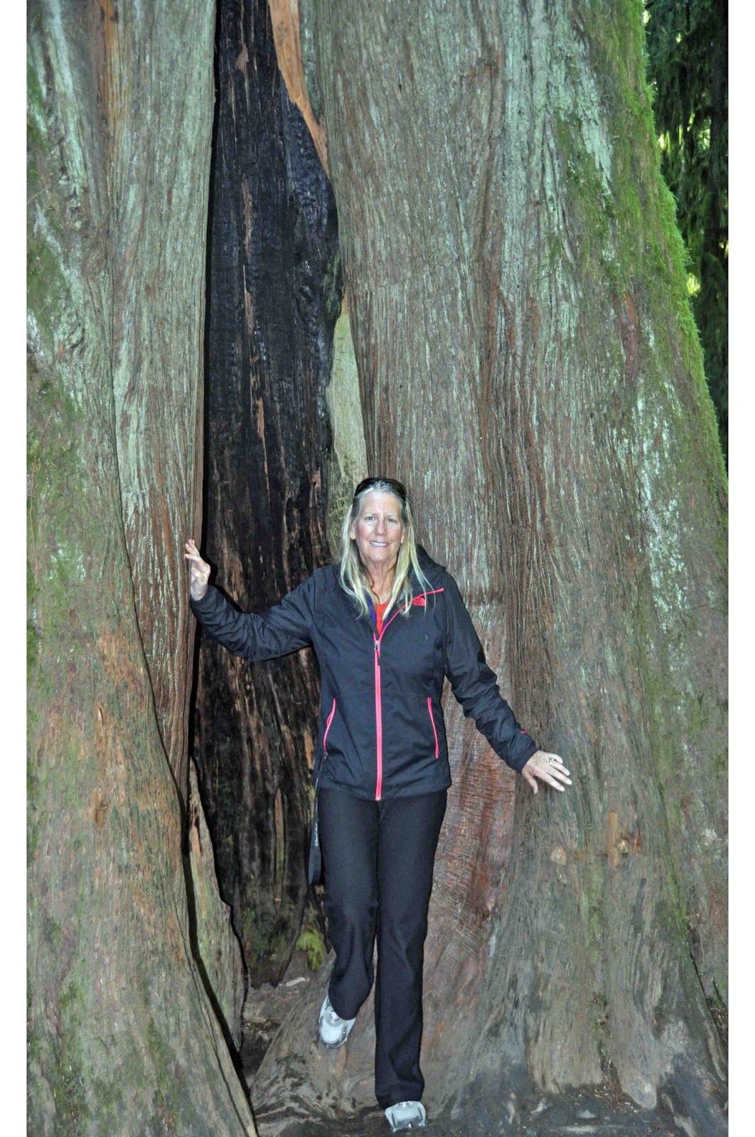
Linda INSIDE Ancient Tree
During our three weeks on the Island’s west and east coasts, we explored the ancient tree stands, including Cathedral Grove (the oldest tree was already large and 300 years old when Columbus landed in America), wherever they survived the logging industry.   We explored the two small towns to the north and south of Pacific Rim National Park, Tofino and Ucluelet.  We hiked portions of the Wild Pacific Trail which extends along much of the rugged western coast of Vancouver; the scenery was breathtaking.   With 14 – 15 foot tides, we were also able to enjoy exploring tide pools on the rocks at low tides…along with all the other “kids”.  
Starfish in Tidal Pool
 
Wild Pacific Trail, Ucluelet, Vancouver Island
Humpback on tail in shallow water, looking around
Whale watching was great, although Linda saw Grey and Humpback whales, we saw no orcas.  Instead of the whale watching boat trip, Bob went salmon fishing (catching this time J) and brought home enough coho and chinook to fill our freezer (usually our fishing trips are not so productive).  We spent one beautiful day (no fog for a change) to take all day round trip boat ride down a very long and deep inlet (in Norway it would qualify as a long “Fiord”) from
Bob with 2 of 4 salmon
Bob with 2 of 4 sPort Alberni in the central part of the Island through the Broken Islands Chain to Ucluelet on the coast.  The city of Port Alberni was heavily damaged in 1964 by three tsunami waves caused by the great Anchorage earthquake that also destroyed much of the Anchorage waterfront (we saw the remaining damage when visiting Anchorage a few years ago).   The tsunami wave height was amplified as it moved further up the narrowing inlet into shallower water.  


Chamainus, City of Murals,  One of 200+
Almost all of the entire population of Vancouver Island lives on the east coast of the island and in the City of Victoria.  We explored lots of small coastal towns.  As the logging industry diminished, the towns needed to find ways to survive, and many chose tourism.  For example, Duncan is the “City of Totem Poles” and Chemainus is the “City of Murals”, and the plans seem to be working.  
Sunken Garden, Butchart

Victoria is a beautiful “city”, really a large town, and the Provincial capital of BC.  Our favorite places included the Empress Hotel and the Provincial Legislature building. The BC museum was fabulous.  The inner harbor is a great walking venue, and the beautiful gardens are everywhere.  They say there is not much snow either, but that is a relative statement on our judgement. 
The world famous Butchart Gardens were a wonder, especially the old quarry, now a fabulous sunken garden; it is a must see.  We attended Sunday service and coffee at Victoria’s St Andrews Presbyterian Church.  Like our own church in St Augustine, this beautiful church building was constructed 125 years ago.
Provincial Legislature Building, Victoria
We toured the Provincial Legislature and we finally understand the Canadian dual governance arrangements, which encompass the Monarchy as a state in the British Commonwealth, alongside the elected political system.  Queen Elizabeth is the Queen of Canada, as well as 16 other countries.  The Governor General is the Queen’s representative in Ottawa for Canada, and each province has a Lieutenant Governor who is the Queen’s representative for that province; all are appointed by the Queen.  The elected officials are voted for democratically.  Interestingly, Prime Minister Trudeau is now trying to change the way election votes are cast and counted to determine who won.  Under the proposed system, his labor party would have won 10% more seats in the last election that they won.   
Sunrise on Pacific Rim National Park Beach
 
As in Banff and Jasper in Alberta, we enjoyed several Royal Canadian Legion posts in a few BC towns we visited. On Vancouver Island, Bob went on a Legion Shirt hunt, and we stopped at several (Linda would say too many) Legions to find a shirt that he liked and in his size.  Finally, success, and we now have an extensive collection of Canadian Legion pins and ribbons – and a hat and a shirt.  J   

We are now headed back to the US.  Communications in Canada has been very difficult.  Since we mostly camped in National or Provincial Parks without any services, we did not have any phone or internet service in our motorhome.  We had to head off to the nearest town and use our phones as a hotspot, or find an internet cafĂ©.  Vancouver Island was impossible.  For some reason, our phones would not connect with the local cell phone provider and we had to find internet cafes (we had too much coffee).  It is great to be back in the US; phones, text, email and even satellite TV in our coach.   We were not able to watch the Olympics very much and the little bit of the first few days we saw was mostly about the Canadians.  It appeared to us that the CBC did a great job in covering the games and especially covering the top athletes, so we saw some of the top US swimmers, gymnasts, and track athletes. 

Vancouver Island West Coast Beach
Having now spent over 2 months in Alberta and British Columbia, we have revised our perspective on Canadians.  We had always thought of them as being very much like Americans.  But that is not entirely true.  Although we share a similar language and similar historical backgrounds; there are a lot of difference in the ways we look at things.  For example; Western Canadian residents are concerned about their “immigration problem”.  They have been overwhelmed by an influx of LEGAL Asians, who are taking their jobs and buying BC real estate at inflated prices.  Interestingly, in a special legislature session in August, BC just passed a 35% tax on all real estate transactions by non-Canadian citizens. The revenue will be used to fund low cost housing.  It is very difficult for younger people to buy a home in Vancouver and Victoria.  Unlike our immigration issues, Canada’s “immigration problem” is from highly educated, workaholic immigrants doing better than they are in school and in the workplace.  

Bottom line, Canadians (even many “conservative” Legion members we met) appear to be much more secular and liberal in their thinking and social values than the “average American”.  In Victoria, we were told by a minister that less than 3% of the residents go to Church.  They are more open to government intervention and higher taxes.  We paid over $5 per gallon of gas versus our $2.50 in the US (diesel is cheaper than gas), and that was in oil resource rich Alberta.   

We are now headed back to the US: North Cascade National Park and then over to the San Juan Islands before heading to Mt Rainier, Seattle and the Olympic peninsula.   

We are having a great trip and we thank God for his blessings and our safety as we continue our travels.
 
Bob and Linda

Wednesday, August 17, 2016

8/16/16 Canadian Rockies: Banff, Kootenay, Yoho, and Jasper National Parks


Bow Lake and Glacier, Jasper NP
From Calgary and Stampede, we headed west to the heart of the Canadian Rockies:  Banff and Jasper National Parks.  Banff and Jasper are almost wholly within Alberta, but the Canadian Rockies spill over into British Columbia and north almost to the Yukon.  To keep the ecosystem complete and to support the wide ranges of the large mammals, Kootenay and Yoho National Parks were added.  The combined parks are much larger than Yellowstone National Park, which is the largest in the continental US.  We spent three weeks among the four parks, traveling south to north.   

Hiking Rainy Day, Lake Johnson, Banff NP
Unfortunately, the weather was not so good most of the time we were here. It was the wettest and coldest July for years.  We worked around the rain as best as possible, and only stayed inside when it absolutely poured.  And we took advantage of every partly sunny day to drive or hike to the best parts of the parks and to take photos.  The good part about the weather, the infamous biting, black flies that usually pester visitors were nowhere to be found.   

Mt Rundle from Vermillion Lakes, town of Banff
The rain also gave us a reason to visit the Royal Canadian Legion posts in Banff and Jasper more frequently than we might have otherwise….which gave us a chance to have great conversations with the locals and a few Canadian WWII, Korean and Afghanistan/Iran veterans.  In Banff, we talked at length with the Banff’s ex-mayor and current Legion president. The city of Banff was carved out of the National Park; therefore, it has all the issues of a small town, PLUS it has to get approval from the National Parks for most things.  Imagine the bureaucracy that has to be dealt with.  It can take 3-4 years to get approval to build.   

Icefields Parkway, Jasper NP
 
Columbia Icefield, Multiple Glacier Arms, Jasper NP
Bow Parkway, Banff NP
Icebergs, Cavell Pond, Cavell Glacier, Mt. Edith Cavell, Jasper NP
The scenery here is gorgeous.  Although the Canadian Rockies are not as high as the American Rockies in absolute terms, the mountains and valleys are steeper and deeper and often much more dramatic.   The glaciers did a wonderful job in sculpting interesting mountain tops, along with hanging valleys, terminal and lateral moraines, and beautiful large aqua glacial lakes.  There are LOTS of existing glaciers from huge icefields, including the Columbia Icefield.  We even hiked to a glacial lake that had icebergs in it from one of the three glaciers feeding the water.  The Columbia Icefields Parkway is one awesome Ahh! to another along its entire 144 mile length. 
 
Mountain Goat, Jasper NP
The ecosystem supports a great variety of wildlife and lots of large mammals.  Most of our wildlife encounters were rarer here than in Yellowstone, even though the park is bigger.  The limited road access into the remote areas make it difficult to encounter animals.  However, we did see black and grizzly bears, mountain goats, elk herds (one day in Jasper they set up camp in our campground), and random mule deer.  One early morning, a black bear crossed the road in front of our car on an almost deserted road.  On the whole, Yellowstone was much better for wildlife viewing, both in the numbers and kinds of wildlife seen. We were lucky because two weeks after we were in Banff’s Tunnel Mountain campground, it was closed because of wolves and the campers evicted for days with everything full (have no idea where they went).  


Lake Louise and Glacier Reflections, early am, Banff NP
Bob and I met in Banff 36 years ago on a ski trip with friends, and then continued dating and married two years later.  We were anxious to visit the places we had been, both when we met and 10 years later when we skied in Banff for our 10th anniversary.  Sadly, we didn’t recognize much of anything.  Of course, it was summer versus winter, but more importantly, most of the facilities had been completely redone (it has been 36 years!).  The Lake Louise ski area looks like most of the newer modern ski villages, and the old lodge is sadly gone.  The biggest shock was that the Banff Springs Hotel and the Lake Louise Chalet were also completely different.  Both had been purchased by the Fairmont Hotel Group and updated.  Most of the beautiful, historic gilded age railroad hotel features were nowhere to be found.  The properties are beautiful, but it would have been nice to keep some of the historic elements in place.  Many of the similar properties in the US have been
Banff Springs Hotel, Banff
able to do that and still modernize.  There were some pictures of the older historic buildings in the hallways…..We enjoyed attending Banff’s St. Paul’s Presbyterian church Sunday morning services and having coffee with members and other visitors including one couple from Florida.
 

Spirit Island, Maligne Lake, Jasper NP
 
We did a LOT of hiking, even in the rain (as long as it wasn’t pouring down).  We experienced great hikes to many moraine lakes, toes of glaciers, glacier overlooks, incredibly deep slot limestone canyons with roaring water from the rain and glacial melt, lots of waterfalls, various hot springs, and sometimes just quiet deep woods.  The boat trip on the largest glacial lake in Jasper, Maligne Lake, with a stop at the famous Spirit Island, was beautiful.   


Mist Rainbow, Athabasca Falls, Jasper NP 
In Yellowstone, we had met someone who asked us which way we were traveling; north to south or south to north.  We told him we were going north.  He said we were lucky.  He had started in the north and was going south, and he felt that the further north you went, the more beautiful it became.  He said everything after Jasper was anticlimactic to him.   He was right.  We would recommend the trip, as we did it, from south to north to be in constant awe of your surroundings….it is way too beautiful to be disappointed by anything.  

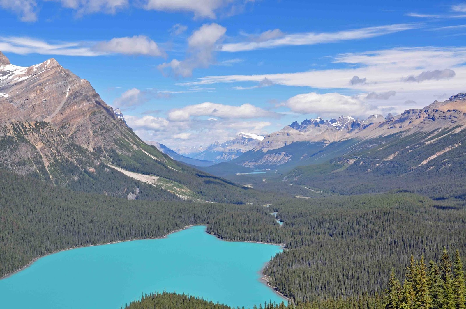
Peyto Lake and Icefields Parkway, Jasper NP
From Jasper, we visited Hinton, Alberta; this was the most northern place we will have visited on our 3-year trip (according to our current plan): 53 DEGREES 24.000 MINUTES NORTH.  This is about the same latitude as the southernmost part of Alaska.  As we have traveled north, the days have grown longer.  It has been light from about 4:00 am until after 11 pm each day.  Bob made a blackout cover for our bathroom skylight so we could get to sleep before midnight and sleep past 5 am.   

Moraine Lake, Banff NP

The Canadian Parks seem to be configured and operated very differently than US National Parks.  The number of roads and trails into the backcountry seem to be more limited, so the few that exist are often very crowded…it is hard to get away from people and to find parking spaces.  The visitor centers do not have exhibits or movies to educate you, but are more like information and reservation centers for restaurants, hotels and tours.  We like the US approach to National Parks better; we especially look forward to the visitor centers and their exhibits and movies about each park you visit.  It is interesting to read numerous articles in local newspapers criticizing the Parks Canada management approach of getting more tourists into already crowned spaces at the expense of conservation and environmental preservation.  We do not know if this is true or not, as much of the parks are not accessible, except by very rugged and remote trails into the backcountry.  Of course, we have no desire to go backpacking to remote campsites – too cold, even in the summer and too rugged for us senior hikers. 


Bow Lake and Glacier Reflections, Jasper NP
In spite of the cold, damp weather, we enjoyed it all. It is now August and still cold and wet – more like spring.  It looks like we will completely miss summer this year (maybe not so bad with the Florida heat this year)…we are too far north to be able to enjoy wearing shorts and tee shirts.   

We are now headed to the Okanagan Wine country to visit some friends and taste some of the best Canadian wine, and then on to Vancouver and Vancouver Island.  We will wear shorts in the Okanagan Valley. 

We thank God for his blessings and our safety as we continue our travels. 

For those of you who might be interested and have the patience to read it, Bob prepared a “Geology” addendum comparing the Canadian Rockies to the American Rockies.  Read below (and enjoy?) at your own risk. 

For those of you who would prefer to read this on-line or on your phones, you can find this update and previous reports at: http://RVRamblin1.blogspot.com.  The blog includes the same copy but a lot of additional pictures and videos as well.    Feel free to pass this on to anyone who might be interested.  

Best, 

Linda and Bob

 
MORE THAN YOU EVER WANTED TO KNOW ABOUT THE CANADIAN ROCKIES VERSUS THE AMERICAN ROCKIES 

For those of you who have not had the pleasure of visiting the Canadian Rockies, here are a few interesting geological observations and comparisons of the Canadian to the American Rockies.  

Having spent a little time in the Colorado and Wyoming Rockies, Bob found it surprising that is no granite or high-grade metamorphic rocks in the Canadian Rocky Mountains which are made almost entirely of sedimentary and low-grade metamorphic rock.  There is lots of granite and metamorphic gneiss and volcanic rock (western portion) in the American Rocky Mountains, unlike the Canadian Rockies. 

To begin it all, there was a much earlier set of American Rockies (Ancestral Rockies) which had been eroded flat by 170 million years ago (mya).   By the time the current (second set) of American Rockies began to rise/uplift 75 mya, (pushed up by all that granite), the Canadian Rockies, including northern Montana and Idaho, were already uplifted and in existence.  The Canadian Rockies stopped growing 35 mya while the American Rockies kept rising until the Pleistocene (about 1.8 mya).   

Generally, the American Rockies have deep faulting to the base of the plate (31+ miles deep) and exposed basement rock.  Interestingly, faults in the Canadian Rockies are shallow (only 6+ miles deep) and there is almost no exposed basement rock. 

During the Pleistocene glacial advances, as recent as 12,000 years ago (there were many earlier glaciers), the continental glacier ice sheets were much thicker in the Canadian Rockies than in America due to fact that they are much further north and the climate was colder.  Therefore, the impact of glaciers on the landscape is much greater in the Canadian Rockies.  

It is good to remember that glaciers do not made the initial landscape; they only “modify” the existing landscape.  For example, water/river erosion makes an original “V” shaped valley; then, the glacier follows and carves the existing valley into the “U” shaped valley we see today.  Almost all of the highest peaks of the Canadian Rockies were buried under thick ice, whereas most of the peaks of the American Rockies (and also the mountain peaks of the Tetons and Glacier NPs) were not under ice sheets, so we see many alpine glacier features on the peaks such as horns, aretes and cirques – some but not so much in the Canadian Rockies.  

While the American Rockies are spectacular with many peaks over 14,000 feet high, we believe the Canadian Rockies are more dramatic to see.  The highest peak in the Canadian Rockies is Mt Robson at 3,454 Meters (those pesky Canadians use Meters, so for us Americans that is 11,501 feet).  Most of the highest Canadian Rockies peaks are 10-11,000 feet elevation; however, the topographic relief (the difference between the highest and lowest elevation) in the Canadian Rockies is typically much greater over a shorter distance than in the American Rockies, making the topography incredibly dramatic and scenic.   

Of course, the jagged limestone and dolostone and quartzite (all sedimentary rock) peaks and hogback ridges rising straight up out of the valleys make beautiful scenery and wonderful experiences.     

The Rocky Mountains of both America and Canada are well worth the trip and are a very rewarding experience for geologists and non-geologists alike.  The above information and more details about the Canadian Rockies can be found in the great 576 page book, Canadian Rockies, Geology Road Tours , by Ben Gadd, Geologist. 


Friday, July 22, 2016

7/22/16 Alberta Canada Plains – Dinosaurs (again) and Cowboys


After almost three weeks in Glacier National Park and its sister park in Canada, Waterton Lakes National Park, we left the mountains and headed east to the Alberta Canadian Plains. Usually the weather is warmer, and we were looking forward to finally wearing shorts and tee shirts to enjoy some warm sunny days.   

Badlands Below Plains, Dinosaur Provincial Park
Both of our first two stops were in the Canadian Badlands, which have unique coulee landscapes and hoodoo rock formations, usually located below the grassy prairie rim in canyons which are not visible until you are literally at the rim.   This region in Alberta is famous for rich deposits of fossils, including dinosaur bones, unearthed at the UNESCO World Heritage Site Dinosaur Provincial Park near Brooks and showcased at the world-class Royal Tyrrell Museum in Drumheller.  

The Badlands of this area of the plains are unique because they are the erosional results of the geologically “recent” merging and subsequent melting of the two great glaciers that covered North America – the Cordilleran Ice Sheet which covered the Rocky Mountains and the western lobe of the Laurentide Ice Sheet which covered much of Canada, about 20,000 to 14,000 years ago.   As we have seen in Glacier National Park and will see in the Canadian Rockies, glaciers are the dominate force and finishing touch to the landscape we see today. 

Dinosaur Fossils "in-situ", Dinosaur Prov Park
The Dinosaur Provincial Park near Brooks is a dramatic example of a Plains Badlands.  We saw burial clusters or swarms of bones in ancient stream beds and fossil digs still being excavated.  We also remember this park because we were the only America license tag in the small campground on July 4th.  Several Canadians wished us Happy Independence Day. 
 
 
Approaching Prairie Storm
Also memorable were the thunderstorms and lighting shows that rolled through every 1.5 to 2 hours for days on end.  We have now experienced the stories about prairie storms; the lighting displays were awesome to watch through our motorhome windshield.  We were very glad we were not in a tent like so many others.  


These visits would complete our exploration of the fossil-filled sedimentary rock from the Cretaceous Period. Many of the fossils are found around the ancient edges (land/sea interface) of the vast inland seas of that Period.  The Western Interior Seaway, also called the Cretaceous Seaway and the North American Inland Sea, was a huge inland sea that split the continent of North America into two parts during most of the Cretaceous Period, from about 145 to 66 million years ago. By 100 million years ago, in the early to mid-Cretaceous, the Rockies were emerging from where the Western Interior Seaway had lain before mountain-building forced it further northeast.


The Cretaceous was a period with relatively warm climate, resulting in high sea levels which caused numerous inland shallow seas.  These oceans and seas were populated with now-extinct marine reptiles and fishes, while dinosaurs continued to dominate on land. At the same time, new groups of mammals and birds, as well as flowering plants, appeared. The Cretaceous ended with a large mass extinction, the Cretaceous–Paleogene extinction event.  

As a note, there have been several large mass extinctions, not just this one which is well known and thought to have been caused by an asteroid contact. The largest include: 444 million years ago, 86% of species lost (Appalachian uplift followed by much lower seas); 375 million years ago, 75% of species lost (new land plants causing algae bloom in oceans with loss of ocean oxygen) ; 251 million years ago, 96% of species lost (Siberian eruption with increased temps and hydrogen sulfide poisoning);  200 million years ago, 80% of species lost (unknown); 66 million years ago, 76% of all species lost (possible asteroid impact).  

Our fossil-exploring locations have now included:
Grand Escalante Staircase Visitor Center, Page, AZ
Dinosaur National Monument, UT /CO border
Fossil Butte National Monument, Kemmerer, WY
Hagerman Fossil Beds National Monument, Hagerman, ID
Dinosaur Provincial Park, Brooks, Alberta, Canada
The Royal Tyrell Museum, Drumheller, Alberta, Canada

As you can see from the  above map, these locations are all on the western edge of the North American Inland Sea. 
Bob and Linda under T Rex Fossil
 
We enjoyed learning about the relative time frames for all these geologic events and periods.  The absolutely best presentation was at the Royal Tyrell Museum which takes you through the vastness of time with a sequential display of the various geologic periods and their representative flora and fauna.  You can actually understand how evolution has progressed through the ages right up to recent loss of ice age animals such as mastodons and sabre tooth tigers, and the advent of man.  As Christians, we believe our God and Creator works in marvelous ways to make this planet and universe.  


Representation Head-Bashed-In Buffalo Jump
 
The Plains are also known for several buffalo “jumps” such as the “Head-Bashed-In-Buffalo-Jump” Provincial Park which we visited just west of Ft. MacLeod.  A Buffalo Jump is where the First Nations, prior to guns and horses, herded hundreds to thousands of bison over a high cliff to plunge to their deaths.  Every part of the bison was used; even most of the bones were used for tools and medicine.  After guns arrived with the white man, Buffalo Jumps were no longer needed when they could easily shoot the bison.  The bison herds were almost eliminated when buffalo coats were in vogue in Europe and back east.  Thank goodness for Yellowstone National Park when we can see animal herds in “natural” ecosystems.   

We moved from the intellectual stimulation of geology and paleontology (which also included a lot of enjoyable hikes), to the pursuit of cowboys, rodeo, and the midway at the Calgary Stampede, the largest rodeo in the world, held annually in Calgary, Alberta.  Our timing was perfect; we were in Calgary for some needed RV repairs while Stampede was ongoing. 

Chuck Wagon in Stampede Parade
In between two RV repairs and a much needed dental cleaning, we had the opportunity to enjoy the opening day parade for the Stampede, which is billed as “Greatest Outdoor Show on Earth” (this was the largest parade we have been to since we attended the Macy’s Thanksgiving Day Parade in New York City in the mid-80s). 


"Cow Head" Pooper Scooper, Stampede Parade
The annual Stampede Parade is a showcase of cowboy and First Nations cultures, complete with the Stampede Queen and her Court, floats, dancers, marching bands, live music, and lots of horses, with the necessary pooper scoopers sprinkled throughout the parade to keep the streets “clean” J. While in Panama in January 2016 we met a former Stampede Queen; it was fun to communicate with her during the week and to see her ride her horse in the Queen’s Alumni section of the parade.

Bareback Bronc Ride, Stampede
After the parade, we attended the opening day afternoon rodeo (held every afternoon for 10 days) with the usual rodeo events:  tie-down roping, team roping, steer wrestling, saddle bronc riding, bareback bronc riding, bull riding and barrel racing.  It was fun to watch the real professionals (interestingly, many/most? from the US), but we had a closer look at what was going on inside the chutes (loading the cowboys onto the animals) at the local rodeo we attended in Cody, WY a few weeks ago.

The 10-day Stampede also included free pancake breakfasts at various locations in Calgary every day (we attended just one), and live music venues (music was played almost everywhere).  Bob’s baseball cap was a rare sight as every man and woman wore cowboy hats, even the anchorman on TV news.  During Stampede, everyone is a cowboy or cowgirl.   We loved the spirit, but does a hat make a cowboy?  We think NOT. We spent one afternoon on the midway, looking at the various wacky and wonderful foods.  We stayed with one of our favorites, BBQ, rather than try deep-fried Oreos or the new deep-fried bacon-wrapped peanut butter covered in chocolate ???  

Chuck Wagon Races, near finish, Stampede
After our afternoon (Senior’s Day with free admission) on the midway and seeing fantastic exhibits we went to the evening show to see what turned out to be our favorite event - the Chuck Wagon Races.  The event started when chuck wagons accompanied the cowboys driving cowherds to Alberta from the south, sometimes all the way from Texas.  The races evolved when the cooks in their chuck wagons started “racing” to be the first to set up at the end of the day and the first to have meals ready to eat, to the now famous Stampede chuck wagon races.  We don’t know if they are held anywhere else.  It is exciting to see 4 large wagons with huge wheels compete in each heat (8 heats per night):  4 wagons with a driver, pulled by 4 horses each, and followed by 2 horse riders behind each wagon to simulate the cowboys trying to be the first to get to the food.  The entire race is pandemonium with wagons, horses and riders in very close quarters racing around a mile long oval track.  A rollover is not unusual.  If you have a chance to watch one, definitely do so (you can google the Stampede and watch online).


Another Approaching Storm over Alberta Canola Fields
The only thing bad about our time in the plains and Calgary was the weather. With the exception of a few days, it rained a lot, and was cold (mid 50s for a high) (News said it was the wettest Stampede in many years, 9 out of 10 days it poured rain, but lucky for us, not on the parade day).  The usually warm weather we expected was nowhere to be found.  Hopefully, the weather will return to the more normal pattern found in the summer soon...we are tired of wearing fleeces, sweatshirts and raingear!


We are now headed to the beautiful Rocky Mountains of Alberta and British Columbia, and their national parks:  Banff, Jasper, Kootenay, and Yoho National Parks.  We met and skied in Banff and Lake Louise 36 years ago, but it will be great to actually see the mountains without so much snow.

We thank God for his blessings and our safety as we continue our travels.

Linda and Bob